 Cart(
Cart(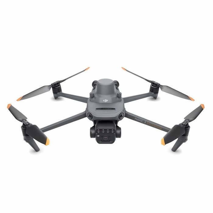
DJI Mavic 3 Multispectral (Care Basic)
It takes the right set of eyes to see problems that are hidden from view. Good thing the leader in drone technology now brings you the DJI Mavic 3 Multispectral.
Power of RGB multispectral cams
There are two ways for Mavic 3 Multispectral to see: one 20MP 4/3 CMOS RGB camera and four 5MP multispectral (green, red, red edge, and near infrared) cameras. For crystal-clear crop growth analysis, it combines an RGB camera with a multispectral camera. Mavic 3M provides the data and precision that agricultural production management demands.
Precision aerial surveying, agricultural growth monitoring, and natural resource surveys are all made possible by these improved imaging systems.
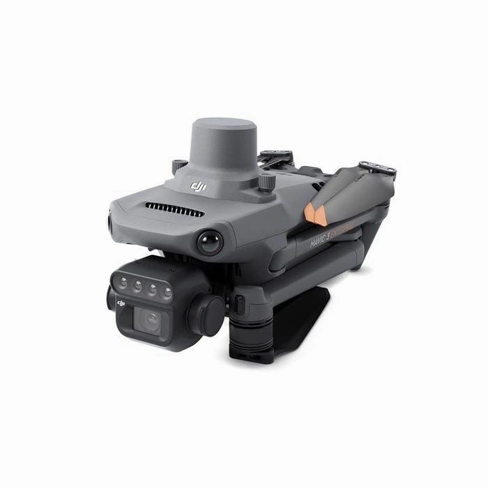
Built-in sunlight sensor
For light adjustment of picture data during 2D reconstruction, the built-in sunlight sensor in DJI Mavic 3 Multispectral records solar irradiance in an image file. As a result, the NDVI results are more accurate, and the accuracy and consistency of data collected over time are also improved.
RTK for centimeter-level positioning
An RTK module is included with Mavic 3M to enable centimeter-level positioning. To precisely pinpoint the location of each camera's imaging center, flight control, the camera, and the RTK module sync in a matter of microseconds. Mavic 3M can now carry out very accurate aerial surveying without the need for ground control points.
Ultra-long battery life
Unlike other survey drones, the DJI Mavic 3 Multispectral has a maximum flight time of 43 minutes. When fully charged, the aircraft can complete mapping operations over an area of 200 hectares in one flight.
You dont even have to worry about getting back up in the air again because the battery supports fast charging. You can use either the 100W Battery Charging Hub for high-efficiency multi-battery fast charging or the 88W aircraft recharging.
Fly with peace of mind
Smooth image transmission and a steady signal are guaranteed by Mavic 3M. In order to achieve 15km ultra-long transmission distances, the O3 transmission integrates two transmitting signals and four receiving signals.
For another layer of safety, the drone features omnidirectional obstacle sensing and terrain-follow mode. The aircraft is equipped with several wide-FOV vision sensors, which enable obstacle avoidance by precisely detecting obstructions in all directions. In terrains with steep slopes, terrain-follow aerial surveying is simple to use.
Agricultural and natural resource applications
Its a wonder that just one drone can be utilized in various agricultural and natural resource applications. The DJI Mavic 3 Multispectral is so powerful you can fly it for different use cases such as the following:
- orchard mapping
- prescription mapping for croplands
- intelligent field scouting
- environmental monitoring
- natural resources survey (water enrichment monitoring, forest distribution surveys, urban green area surveys, and more)
- 1x Aircraft (RTK module and microSD card installed)
- 1x Remote controller
- 1x Pair of propellers
- 1x Charger
- 1x Power cable
- 1x USB-C cable
- 1x USB-C to USB-C cable
- 1x Carrying case
- 1x Screwdriver
- 1x Manuals
Aircraft
Net Weight (with propellers and RTK module)[1]
- 951 g
Max Takeoff Weight
- 1,050 g
Dimensions (Folded/Unfolded)
- Folded (without propellers): 22396.3122.2 mm (LengthWidthHeight)
Unfolded (without propellers): 347.5283139.6 mm (LengthWidthHeight)
Diagonal Length
- Diagonal: 380.1 mm
Max Ascent Speed
- 6 m/s (Normal Mode)
8 m/s (Sport Mode)
Max Descent Speed
- 6 m/s (Normal Mode)
6 m/s (Sport Mode)
Max Flight Speed (at sea level, no wind)
- 15 m/s (Normal Mode)
Flying forward: 21 m/s, flying sideways: 20 m/s, flying backwards: 19 m/s (Sport mode)[2]
Max Wind Speed Resistance
- 12 m/s[3]
Max Take-off Altitude Above Sea Level
- 6000 m (without a payload)
Max Flight Time (without wind)
- 43 minutes[4]
Max Hover Time (without wind)
- 37 minutes[4]
Max Flight Distance
- 32 km[6]
Max Tilt Angle
- 30 (Normal Mode)
35 (Sport Mode)
Max Angular Velocity
- 200/s
GNSS
- GPS Galileo BeiDou GLONASS (GLONASS is supported only when RTK module is enabled)
Hovering Accuracy Range
- Vertical: 0.1 m (Vision Positioning enabled); 0.5 m (GNSS Positioning enabled); 0.1 m (D-RTK enabled)
Horizontal: 0.3 m (Vision Positioning enabled); 0.5 m (HD Positioning enabled); 0.1 m (RTK enabled)
Operating Temperature
- -10 to 40 C (14 to 104 F)
Internal Storage
- N/A
Motor Model Number
- 2008
Propeller Model Number
- 9453F Enterprise Edition
Light Sensor
- Built-in module
RGB Camera
Image Sensor
- 4/3 CMOS
Effective Pixels: 20 MP
Lens
- FOV: 84
Equivalent focal length: 24 mm
Aperture: f/2.8 to f/11
Focus: 1 m to
ISO Range
- 100-6400
Shutter speed
- Electronic shutter: 8-1/8000 s
Mechanical shutter: 8-1/2000 s
Max Image Size
- 52803956
Photo Shooting Mode
- Single shot: 20 MP
Timelapse: 20 MP
JPEG: 0.7/1/2/3/5/7/10/15/20/30/60 s
JPEG RAW: 3/5/7/10/15/20/30/60 s
Panorama: 20 MP (original material)
Video Resolution
- H.264:
4K: 38402160@30fps
FHD: 19201080@30fps
Max Video Bitrate
- 4K: 130Mbps
FHD: 70Mbps
Supported File System
- exFAT
Image Format
- JPEG/DNG (RAW)
Video Format
- MP4 (MPEG-4 AVC/H.264)
Multispectral Camera
Image Sensor
- 1/2.8-inch CMOS, effective pixels: 5 MP
Lens
- FOV: 73.91 (61.2 x 48.10)
Equivalent focal length: 25 mm
Aperture: f/2.0
Focus: Fixed Focus
Multispectral Camera Band
- Green (G): 560 16 nm;
Red (R): 650 16 nm;
Red Edge (RE): 730 16 nm;
Near infrared (NIR): 860 26 nm;
Gain Range
- 1x-32x
Shutter Speed
- Electronic Shutter: 1/30~1/12800 s
Max Image Size
- 25921944
Image Format
- TIFF
Video Format
- MP4 (MPEG-4 AVC/H.264)
Photo Shooting Mode
- Single shot: 5 MP
Timelapse: 5 MP
TIFF: 2/3/5/7/10/15/20/30/60 s
Video Resolution
- H.264
FHD: 1920 x 1080@30fps
Video content: NDVI/GNDVI/NDRE
Max Video Bitrate
- Stream: 60 Mbps
Gimbal
Stabilization System
- 3-axis mechanical gimbal (tilt, roll, pan)
Mechanical Range
- Tilt: -135 to 45
Roll: -45 to 45
Pan: -27 to 27
Controllable Range
- Tilt: -90 to 35
Pan: Uncontrollable
Max Control Speed (tilt)
- 100/s
Angular Vibration Range
- 0.007
Sensing System
Sensing System Type
- Omnidirectional binocular vision system, with an infrared sensor at the bottom of the aircraft
Forward
- Distance Measuring Range: 0.5 m to 20 m
Detection Range: 0.5 m to 200 m
Effective Obstacle Avoidance Speed: Flight Speed 15 m/s
FOV: Horizontal 90, vertical 103
Backward
- Distance Measuring Range: 0.5 m to 16 m
Effective Obstacle Avoidance Speed: Flight speed 12 m/s
FOV: Horizontal 90, vertical 103
Lateral
- Distance Measuring Range: 0.5 m to 25 m
Effective Obstacle Avoidance Speed: Flight speed 15 m/s
FOV: Horizontal 90, vertical 85
Upward
- Distance Measuring Range: 0.2 m to 10 m
Effective Obstacle Avoidance Speed: Flight Speed 6 m/s
FOV: Front and rear 100, left and right 90
Downward
- Distance Measuring Range: 0.3 m to 18 m
Effective Obstacle Avoidance Speed: Flight speed 6 m/s
FOV: Front and rear 130, left and right 160
Operating Environment
- Front, Rear, Left, Right, Above: Surfaces with clear patterns and adequate lighting (> 15 lux, environments with normal indoor fluorescent light exposure)
Below: Surfaces with diffuse reflection material and a reflectivity of >20% (such as walls, trees, people, etc.); Adequate lighting (>15 lux, environments with normal indoor fluorescent light exposure)
Video Transmission
Video Transmission System
- DJI O3 Image Transmission Industry Edition
Live View Quality
- Remote Controller: 1080p/30fps
Operating Band[7]
- 2.400-2.4835 GHz
5.725-5.850 GHz
Max Effective Signal Distance (Unobstructed, No interference)[8]
- FCC: 15 km
CE: 8 km
SRRC: 8 km
MIC: 8 km
Max Transmission Distance (Obstructed)[9]
- Strong Interference (urban landscapes, residential areas, etc.): 1.5-3 km (FCC/CE/SRRC/MIC)
Medium Interference (suburban landscapes, city parks, etc.): 3-9 km (FCC), 3-6 km (CE/SRRC/MIC)
Weak Interference (remote fields, open farmland, etc.): 9-15 km (FCC), 6-8 km (CE/SRRC/MIC)
Max Download Speed
- 15 MB/s (with DJI RC Pro Industry Edition)
Latency (depending on environment and mobile device)
- Approximately 200 milliseconds
Antennas
- 4 antennas, 2 transmitting and 4 receiving
Transmitter Power (EIRP)
- 2.4 GHz: <33 dBm (FCC), <20 dBm (CE/SRRC/MIC)
5.8 GHz: <33 dBm (FCC), <30 dBm (SRRC), <14 dBm (CE)
Other
- Supports the DJI Cellular module
DJI RC Pro Enterprise Edition
Image Transmission System
- DJI O3 Image Transmission Industry Edition
Max Effective Signal Distance (Unobstructed, No interference)[8]
- FCC: 15 km
CE: 8 km
SRRC: 8 km
MIC: 8 km
Operating Band of Image Transmission[7]
- 2.400-2.4835 GHz
5.725-5.850 GHz
Antennas
- 4 antennas, 2 transmitting and 4 receiving
Operating Band of Image Transmission and Transmitter Power (EIRP)
- 2.4 GHz: <33 dBm (FCC); <20 dBm (CE/SRRC/MIC)
5.8 GHz: <33 dBm (FCC); <14 dBm (CE); <23 dBm (SRRC)
Wi-Fi Protocol
- 802.11 a/b/g/n/ac/ax
Support 22 MIMO Wi-Fi
Wi-Fi Operating Band[7]
- 2.400-2.4835 GHz
5.150-5.250 GHz
5.725-5.850 GHz
Wi-Fi Operating Band and Transmitter Power (EIRP)
- 2.4 GHz: <26 dBm (FCC); <20 dBm (CE/SRRC/MIC)
5.1 GHz: <26 dBm (FCC); <23 dBm (CE/SRRC/MIC)
5.8 GHz: <26 dBm (FCC/SRRC); <14 dBm (CE)
Bluetooth Protocol
- Bluetooth 5.1
Bluetooth Operating Band
- 2.400-2.4835 GHz
Bluetooth Transmitter Power (EIRP)
- <10 dBm
Screen Resolution
- 19201080
Screen Size
- 5.5 inches
Screen Frame Rate
- 60 fps
Screen Brightness
- 1,000 nits
Touch-Screen
- 10-point multi-touch
Battery
- Lithium-ion battery (5000 mAh, 7.2 V)
Charging Type
- 100W Battery Charging Hub or USB charger with 12V or 15V specifications is recommended
Rated Power
- 12 Watts
Storage Capacity
- Internal Memory (ROM): 64 GB
Supports microSD card usage to increase storage capacity
Charging Time
- Approx. 1.5 hours (measured when only using the 100W Battery Charging Hub to charge the remote control, or when using a 15V USB charger)
Approximately 2 hours (measured using a 12V USB charger)
Approximately 2 hours and 50 minutes (measured using the 100W Battery Charging Hub to charge the aircraft and remote control at the same time)
Operating Time
- Approx. 3 hours
Video Output Port
- Mini-HDMI Port
Operating Temperature
- -10 to 40 C (14 to 104F)
Storage Temperature Range
- <1 month: -30 to 60 C (-22 to 140 F)
One to three months: -30 to 45 C (-22 to 113 F)
Three to six months: -30 to 35 C (-22 to 95 F)
More than six months: -30 to 25 C (-22 to 77 F)
Charging Temperature
- 5 to 40 C (41 to 104 F)
Supported DJI Aircraft[10]
- DJI Mavic 3E
DJI Mavic 3T
DJI Mavic 3M
GNSS
- GPS Galileo GLONASS
Dimensions
- Antenna is folded and no control sticks are installed:
183.27137.4147.6 mm (LengthWidthHeight)
Antenna unfolded and control sticks are installed:
183.27203.3559.84 mm (LengthWidthHeight)
Weight
- Approx. 680 g
Model Number
- RM510B
Storage
Supported microSD Cards
- Aircraft:
Please use a memory card with a speed rating of V30 or higher, or use a memory card from the recommended list
Recommended microSD Cards
- Remote Controller:
SanDisk Extreme PRO 64GB V30 A2 microSDXC
SanDisk High Endurance 64GB V30 microSDXC
SanDisk Extreme 128GB V30 A2 microSDXC
SanDisk Extreme 256GB V30 A2 microSDXC
SanDisk Extreme 512GB V30 A2 microSDXC
Lexar 667x 64GB V30 A2 microSDXC
Lexar High-Endurance 64GB V30 microSDXC
Lexar High-Endurance 128GB V30 microSDXC
Lexar 667x 256GB V30 A2 microSDXC
Lexar 512GB V30 A2 microSDXC
Samsung EVO Plus 64GB V30 microSDXC
Samsung EVO Plus 128GB V30 microSDXC
Samsung EVO Plus 256GB V30 microSDXC
Samsung EVO Plus 512GB V30 microSDXC
Kingston Canvas Go! Plus 128GB V30 A2 microSDXC
Kingston Canvas React Plus 128GB V90 A1 microSDXC
Aircraft:
SanDisk Extreme 32GB V30 A1 microSDHC
SanDisk Extreme PRO 32GB V30 A1 microSDHC
SanDisk Extreme 512GB V30 A2 microSDXC
Lexar 1066x 64GB V30 A2 microSDXC
Kingston Canvas Go! Plus 64GB V30 A2 microSDXC
Kingston Canvas React Plus 64GB V90 A1 microSDXC
Kingston Canvas Go! Plus 128GB V30 A2 microSDXC
Kingston Canvas React Plus 128GB V90 A1 microSDXC
Kingston Canvas React Plus 256GB V90 A2 microSDXC
Samsung PRO Plus 256GB V30 A2 microSDXC
Battery
Capacity
- 5000 mAh
Standard Voltage
- 15.4 V
Max Charging Voltage
- 17.6 V
Battery Type
- LiPo 4S
Chemical System
- Lithium Cobalt
Energy
- 77 watt-hours
Weight
- 335.5 g
Charging Temperature
- 5 to 40 C (41 to 104 F)
Battery Charger
Input
- 100V to 240V (AC), 50Hz to 60Hz, 2.5A
Output Power
- 100 Watts
Output
- Maximum output power of 100 Watts (total)
When both the ports are used, the maximum output power of one interface is 82 W, and the charger will dynamically allocate the output power of the two interfaces according to load power.
Charging Hub
Input
- USB-C: 5V to 20V, 5.0A
Output
- Battery Port: 12V to 17.6V, 8.0A
Rated Power
- 100 Watts
Charging Type
- 3 batteries on charging rotation
Charging Temperature
- 5 to 40 C (41 to 104 F)
RTK Module
Dimensions
- 50.240.266.2 mm (LengthWidthHeight)
Weight
- 242 g
Interface
- USB-C
Power
- Approximately 1.2 watts
RTK Position Accuracy
- Fixed RTK:
Horizontal: 1 cm 1 ppm; Vertical: 1.5 cm 1 ppm
Notes
Footnotes
- 1. Standard weight of the aircraft (including battery, propellers, and microSD card). The actual product weight may vary due to differences in batch materials and external factors. Use for reference only.
2. The max speed in the EU cannot exceed 19 m/s.
3. Max wind resistance during takeoff and landing.
4. Data measured using the DJI Mavic 3M in a wind-free environment while flying at sea level at a constant speed of 36 kph until there was 0% power remaining. For reference only. Please pay attention to Return to Home prompts in the DJI Pilot 2 app when flying.
5. Data measured using the DJI Mavic 3M in a wind-free environment hovering over the sea level until there was 0% power remaining. For reference only. Please pay attention to Return to Home prompts in the DJI Pilot 2 app when flying.
6. Data measured using the DJI Mavic 3M in a wind-free environment while flying at sea level at 57.6 kph until there was 0% power remaining. For reference only. Please pay attention to Return to Home prompts in the DJI Pilot 2 app when flying.
7. In some countries, the 5.1/5.8GHz frequencies are prohibited, or the 5.1GHz frequency is only allowed for indoor use. Please refer to local laws and regulations before use.
8. Data measured flying in an unobstructed outdoor environment free of interference. It shows the farthest communication range for one-way, non-Return to Home flights under each standard. Please pay attention to Return to Home prompts in the DJI Pilot 2 app when flying.
9. Data measured in an unobstructed environment with typical interference under various standards. The actual flight distance may vary and is for reference only.
10. The DJI RC Plus will support more DJI aircraft in the future.


")


