 Cart(
Cart(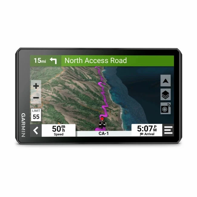
Garmin Zumo XT2 MT-S Motorcycle Navigator
Rev your engine and explore far and wide with the Garmin Zumo XT2 MT-S motorcycle navigator. Its robust 6 display is glove-friendly and designed to help you find the most thrilling routes, no matter where your adventures take you.
- The bright 6 display is easy to read, no matter the weather or light conditions.
- Create custom routes with the visual route planner.
- Find the twists and turns with the Garmin Adventurous Routingsetting.
- See popular moto paths to discover new places to ride.
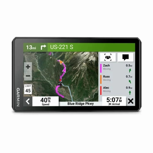
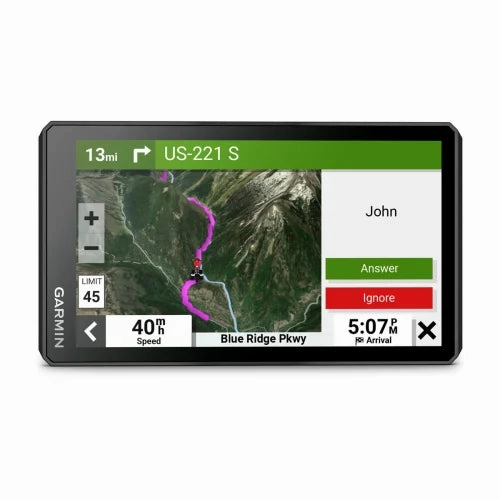
- Start a group ride to see positions of other riders on the zmo XT2 display1.
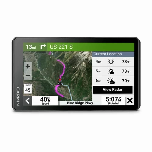
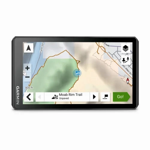
- Switch from North America street maps to topographic maps to satellite imagery with just a tap.
What's in the box
- zmo XT2
- Motorcycle mount and hardware
- Motorcycle power cable
- USB cable
- Documentation
ULTRABRIGHT DISPLAY
The 6 display is 15% larger than previous models and features an even brighter HD resolution in landscape or portrait mode.
DESIGNED TO ENDURE
Rain? Vibration? Dust? Doesnt matter. This device is built to withstand all kinds ofand rough terrain.
VISUAL ROUTE PLANNER
Plan a custom route on the device, or use thewith a compatible smartphone.
SIMPLE MAP SWITCHING
Quickly toggle between on-road maps, topographic maps and satellite imagery, so you can always have the perfect map for your ride
GROUP TRACKING
Use the Tread app on your smartphone and/or zmo XT2 device to track friends with the Group Ride Mobile feature1. Or, use theaccessory2(sold separately) for tracking other zmo XT2-equipped riders with no cellular coverage needed.
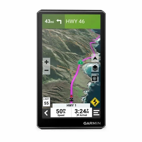
SATELLITE IMAGERY
Use satellite imagery from around the world to help you navigate. Download the maps directly to your device via Wi-Fitechnology3. No annual subscription required.
POPULAR PATHS
See popular moto paths ridden by other riders to find new and exciting routes to explore.
GARMIN ADVENTUROUS ROUTING
Straight roads are boring. Find the most thrilling routes with hills, curves and sights, and choose from 4 levels of difficulty.
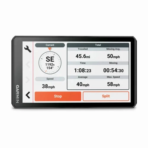
RIDE SUMMARIES
Use the Tread app to review your ride details, including speed, acceleration, decelerations, elevation and more.
TRACK RECORDER
Record your ride data such speed, distance, acceleration and more and share the details with friends on Tread app.
SHARE YOUR FAVORITE ROUTES
Easily send GPX files from your phone or third-party sources to your zmo XT2 navigator. Share GPX files with fellow riders by using the Tread app.
General | |
| DIMENSION | 6.15"W x 3.5"H x 1"D (15.6 x 8.9 x 2.5 cm) |
|---|---|
| DISPLAY SIZE | 5.3"W x 3.0" H (13.3 x 7.5 cm); 6" diag (15.3cm) |
| DISPLAY RESOLUTION | 1280 x 720 pixels |
| DISPLAY TYPE | multi-touch, glass, high brightness HD color TFT with white backlight |
| DUAL-ORIENTATION DISPLAY | |
| WEIGHT | 12 ounces (340 g) |
| IPX7 | |
| BATTERY TYPE | rechargeable lithium-ion |
| BATTERY LIFE | up to 6 hours (up to 3.5 hours at 100% backlight) |
| DROP RATING | MIL-STD-810 |
| HANDLEBAR MOUNT (UP TO 1") | |
Maps & Memory | |
| PRELOADED STREET MAPS | |
|---|---|
| DATA CARDS | microSD card (not included) |
| 3D TERRAIN | |
| INTERNAL STORAGE | 32 GB |
| ABILITY TO ADD MAPS | |
| EXTERNAL MEMORY STORAGE | yes (256 GB max microSD card) |
| INCLUDES MAP UPDATES | |
| DOWNLOADABLE SATELLITE IMAGERY | yes (BirdsEye) |
Sensors | |
| GPS | |
|---|---|
| GALILEO | |
| 10 HZ MULTI-GNSS POSITIONING | |
Outdoor Recreation | |
| POINT-TO-POINT NAVIGATION | |
|---|---|
| PRELOADED TOPOGRAPHICAL MAPS | |
| NAVIGATE-A-TRACK NAVIGATION | |
Navigation Features | |
| VISUAL ROUTE PLANNER | |
|---|---|
| GARMIN REAL DIRECTIONS LANDMARK GUIDANCE | |
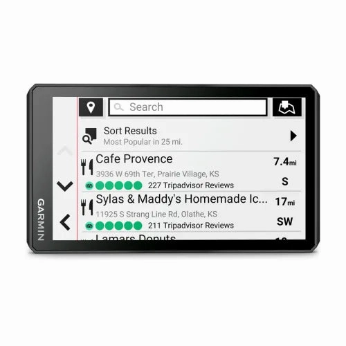
| TRIPADVISOR TRAVELER RATINGS | |
| ROUTE SHAPING THROUGH PREFERRED CITIES/STREETS | |
| INCLUDES TRAFFIC | yes (with Garmin Tread app) |
| LANE ASSIST WITH JUNCTION VIEW (DISPLAYS JUNCTION SIGNS) | |
| BLUETOOTH PAIRING | yes (works with BLUETOOTH-compatible helmet, headset or smartphone. BLE capable.) |
| SPEED LIMIT INDICATOR (DISPLAYS SPEED LIMIT FOR MOST MAJOR ROADS IN THE U.S. AND EUROPE) | |
| DRIVER ALERTS FOR SHARP CURVES, SCHOOL ZONES, RED LIGHT AND SPEED CAMERA WARNINGS AND MORE | |
Advanced Features | |
| SMART NOTIFICATIONS VIA APP | |
|---|---|
| WI-FI MAP AND SOFTWARE UPDATES | |
| ACCESS TO LIVE SERVICES VIA APP (TRAFFIC, WEATHER, ETC.) | |
Motorcycle Features | |
| CONTROL MUSIC AND MEDIA FROM SMARTPHONE OR MP3 PLAYER | |
|---|---|
| SUNLIGHT READABLE AND WEATHER RESISTANT | |
| GARMIN ADVENTUROUS ROUTING | |
| RIDER ALERT WARNINGS FOR SHARP CURVES, STATE HELMET LAWS, SPEED CAMERAS AND MORE | |
| PLANNED & DYNAMIC FUEL STOPS | |
| MOTORCYCLE OR POWERSPORTS SPECIFIC POINTS OF INTEREST FOR CYCLE REPAIR SERVICES, DEALERS AND MORE | |
| HELMET LAW NOTIFICATIONS | |
| POPULAR PATHS (MOTO) | |
| ELEVATION PROFILE | |
| ROUND TRIP ROUTING | |
| SERVICE HISTORY LOG | |
| TRACK SUPPORT | |
| SUPPORT | |
| TOPO MAP SUPPORT | |
| WIRELESS ANT TECHNOLOGY | |
Adventure Features | |
| PAIR WITH COMPATIBLE INREACH DEVICES | |
|---|---|
| PAIR WITH GARMIN POWERSWITCH DIGITAL SWITCH BOX | |
| COMPATIBLE WITH GROUP RIDE RADIO | yes () |
| GROUP RIDE MOBILE | |
| TRACK RECORDER (BREADCRUMBS) | |
| COMPATIBLE WITH THE GARMIN TREAD APP FOR ROUTE PLANNING AND DATA MANAGEMENT (WAYPOINTS, TRACKS, AND ROUTES) | |
| IOVERLANDER POINTS OF INTEREST | |
| ULTIMATE PUBLIC CAMPGROUNDS | |
| GLOVE-FRIENDLY TOUCHSCREEN | |
Group Ride Radio | |
| RADIO FREQUENCY BAND | compatible with Group Ride Radio |
|---|---|
| GROUP RIDE TRACKING | compatible with Group Ride Radio |
| GROUP RIDE VOICE COMMUNICATIONS | compatible with Group Ride Radio |
| RADIO TRANSMITTED CANNED MESSAGES | compatible with Group Ride Radio |


