 Cart(
Cart(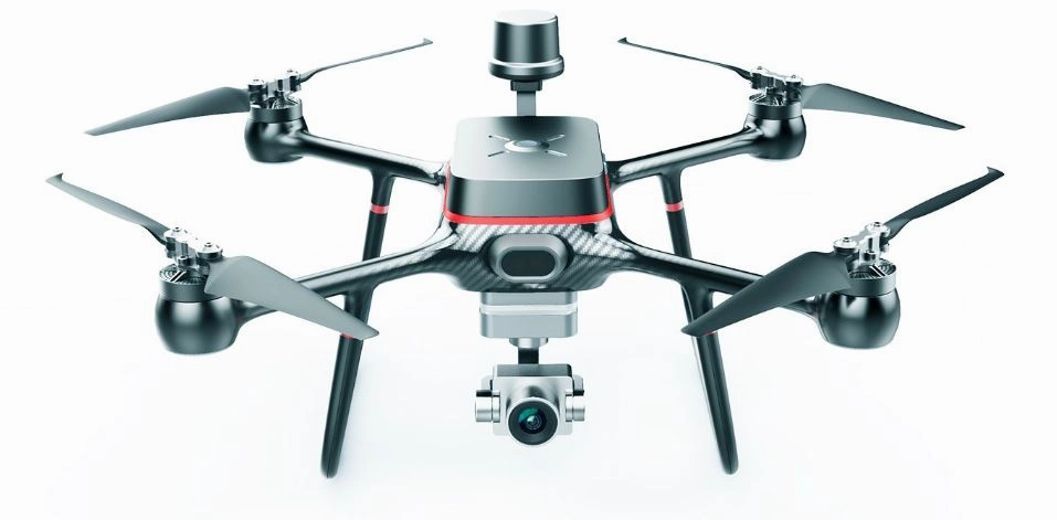
R500 RTK Surveying and Mapping UAV
Product Description
Meet the R500 RTK drone - designed to help you attain new heights with ease. The lightweight carbon fiber fuselage design makes it easy to fly, while its Grade 7 wind resistance allows for smooth operation even in windy conditions. Equipped with a three-axis small gimbal, the drone supports a range of cameras including 6K ultra HD, starlight night vision, and infrared thermal imaging. Ready to fly and with up to 60 minutes of flight time, the R500 RTK drone is the perfect tool to help you drive the wind and achieve your goals.
- Integrated carbon Fiber fuselage
- Network RTK
- 12KM Max Transmission
- 6K 25fps Video
- 60-min Max Flight Time
- IP54 Rating
Born for aerial survey
R500 is a small, multi-rotor, high-precisionaerial surveyuav for low altitudephotogram-metry applications. Equipped with centimeter-level navigation and positioningsystem and high-performance imaging system, it is portable and easy to use to comprehensively improve the efficiencyof aerial survey.
Basic Surveying and mapping
Fast data collection, greatly reduce field costs, flexible generation of a variety of surveying and mapping results
Spatial planning
UAV fast 2D and 3D precise modeling is combined with a variety of geographical data to intuitively display the planning effect, making the design more scientific and efficient.
Engineering surveying and mapping
Enhance the digital level of engineering construction, provide comprehensive information support for design, construction and operation.
Natural resource survey
Efficient data collection, automated information processing, and unmanned aerial vehicle solutions make it possible to refine large-scale natural resource surveys.
12KM Transmission
R500 RTK UAV adopts 2.4G long-distance transmission system, which can transmit the maximum map distance up to 12 KM. Strong anti-interference, stable and reliable transmission.
Network RTK (optional)
Integrated new RTK module, with strong anti-magnetic interference capability and accurate positioningcapability, providing real-time centimeter-level positioning data.
Stable and reliable flight control system
The latest control navigation algorithm can realize real-time mutual backup of data. No need to install shock absorption design, giving aircraft more reliability, for aerial photography top provide stable flight experience.
Intelligent environment awareness
The forward-looking obstacle avoidance module and the down-looking infrared height setting system can make the aircraft positioning more accurate, perceive the surrounding flying obstacles, and reduce the accidents caused by operation errors.
Geographic information mapping
Its subverts the traditional manual surveying and mapping operation mode, greatly improves the level of automation and information technology of surveying and mapping, and comprehensively improves the efficiency of surveying and mapping.
Specifications
Aerocraft
| Symmetrical motor wheelbase | 460mm |
| Body size | 367mm*367mm*228mm |
| electric machinery | KV value 650rpm/V |
| Electric regulation | Continuous current 45A |
| Propeller specifications | Diameter * pitch: 11 * 4.5 inch |
| Normal takeoff weight | 1.38kg (including battery and PTZ) |
| Maximum takeoff weight | 2.0kg |
| Ascending speed | Factory default 5 m/s, (3~8m/s adjustable) |
| Descending speed | Factory default 3 m/s, (3~8m/s adjustable) |
| Horizontal flight speed | GPS mode: 5m/s; Motion mode: factory default 10m/s (5~20m/s adjustable); Attitude mode: 15m/s (windless environment) |
| Maximum tilt angle | GPS mode: 25 ; Motion mode: 30 ; Attitude mode: 30 ; |
| Maximum rotation angular velocity | 150/s |
| Maximum flight altitude | 4500m |
| Maximum tolerable wind speed | 17m/s |
| Maximum endurance | 60 minutes (no load, no camera PTZ attached); 50 minutes (mount the camera PTZ); |
| Operating ambient temperature | -10 to 40 |
| positioning accuracy | GPS: vertical 1.5 m, horizontal 0.4 m (GPS positioning works normally) |
| Cooperate with network RTK | Horizontal 1cm 1ppm, vertical 2cm 1ppm (GPS positioning works normally, network RTK connection works normally) |
Forward vision obstacle avoidance
| Obstacle perception range | 12m |
| FOV | Horizontal 30 , vertical 2.4 |
| Measuring frequency | 100 Hz |
Downward elevation
| Height measurement range | 12 m |
| Precise hover range | 0.1m |
| Measuring frequency | 100Hz |
Remote controller WKRC-H12
| model | WKRC-H12 |
| working frequency | 2400MHz to 2483MHz |
| Maximum communication distance | 12Km (open without shelter and electromagnetic interference) |
| Display device | 5.5 inch 1920 * 1080 1000NITS highlight display |
| Charging interface | TYPE-C |
| Battery | 3.7V 10000mAh LiPo 1S |
| Operating ambient temperature | -10 to 40 |
| Charging ambient temperature | 5 to 40 |
| weight | 530g |
| size | 190*152*94mm |
Network RTK (optional)
| Use frequency band | GPS: L1 /L2/L5 GLONASS:F1/F2 BeiDou: B1/B2/B3 Galileo:E1/E5 |
| positioning accuracy | Horizontal: 1cm 1ppm Vertical: 2cm 1ppm; 1ppm: the accuracy will change by 1mm for every 1km increase. |
| Positioning update rate | 1000HZ |
| cold boot | 45s |
| Hot start | 10s |
| Recapture | 1s |
| Initialization Reliability | 99.9% |
| Differential data transmission format | RTCM 2.X/3.X |
| data link | 4G |
| Communication distance | Unlimited distance (with 4G network signal) |
| Operating ambient temperature | 10 to 45 |
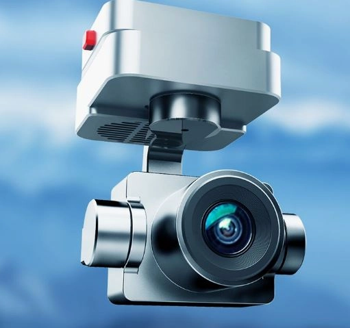
6K camera
| Image sensor | 1-inch SONY back illuminated CMOS |
| camera lens | FOV85; Equivalent 9mm focal length; F/3.5 Aperture |
| photograph | 21 megapixel support |
| video recording | 6K (5480*3648) 25fps 4K (3860*2160) 25fps/30fps/60fps |
| Zoom | 25x lossless digital zoom |
| video coding | H264H265 |
| Supports file system formats | exfat |
| Video format | MP4 |
| Picture Format | JPG |
| Supported memory card types | Micro SD card, which supports 512G at most and has a transmission speed of Class10 or above or reaches UHS-1 rating |
Intelligent flight battery
| Voltage | 22.2V |
| capacity | 7000mAh |
| Battery type | LiPo 6S |
| energy | 155.4Wh |
| Charging ambient temperature | 5 to 40 |
 DDR5 RAM")


 (Refurbished)")

